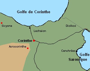
 Pass the mouse over the red dots on this map for some more information, in particular the geographical coordinates. Pass the mouse over the red dots on this map for some more information, in particular the geographical coordinates.
Nota Bene: see also our "satellite view" map or Greek archaeological sites and museums.
|
Corinth is of course the site of the greco-roman city, its museum, but also the upper city, Acrocorinth. From the road which leads to the port of Lechaion remains only the section which leaves the city. On the isthmus, rare vestiges of the diolkos (the terrestrial way for boats) remain visible.
Around Corinth remain a lot of scattered small sites. Let us mention, on northern bank of the gulf of Corinth, the Heraion de Perachora, and towards the south, in the direction of Argolide, the interesting site of Nemea and its museum.
A nice place to visit, the site of Sicyone (cf. map) and its small museum, on the southern bank of the gulf of Corinth, though a little difficult to find. Founded by Ionians 20 centuries B.C., the city was a cultural capital well before Athens. Its school of sculpture, which Polyclete came from, its bronze and ceramics workshops were famous. The art of painting was also said to be born there.
|